中文官网

DLD-50D 2D TOF LiDAR — Navigation & Mapping to 50 m

The sensor we recommend when a mobile robot has to know where it is: navigation-grade repeatability, a wide 280° window, and a commissioning workflow that takes minutes, not days.

  • ±20 mm repeatability — steadiest scans in our LiDAR range
  • 50 m @90% remission, guaranteed 20 m on dark 10% targets
  • 225 kHz ranging engine, 0.08° finest resolution
  • Sunlight-immune above 100,000 lux, IP67 sealed
  • Ethernet point clouds (TCP 2368) + free SimiView + SDK
Share this pageEmailWhatsAppLinkedIn
DLD-50D 2D TOF navigation and mapping LiDAR

Engineered Around the Navigation Stack

Mapping quality is decided by how consistently a LiDAR reports the same wall at the same distance, revolution after revolution. The DLD-50D was tuned for exactly that: ±20 mm repeatability from a 225 kHz time-of-flight ranging engine, streamed over standard Ethernet so your SLAM software consumes raw point clouds with no fieldbus translation layer in between.

The 280° aperture is wider than a conventional 270° scanner — mounted on a vehicle's front corner, one unit sees the travel path and both flanks, leaving only an 80° wedge (kept against the chassis) unobserved. Range is rated two ways, and we publish both: 50 m on 90% remission surfaces and a guaranteed 20 m on dark 10% remission targets — design dark-scene layouts to the second number.

This is a perception/measurement LiDAR, not an IEC 61496 certified safety component; do not use it as the sole means of personnel protection. For machine safety functions, see the ST27 Type 3 safety laser scanner.

Is the DLD-50D the Right Fit for Your Robot?

Start with the data your controller needs, then check the scene it must see. A good sample evaluation should answer these three questions before you commit to a fleet rollout.

Do you need a scan, or a switching signal?

Choose this Ethernet-output model when your computer will process profiles for mapping, localization or measurement. If the controller needs discrete NPN/PNP signals, compare the DLD50T8N / DLD50T8P and confirm its output logic separately. These are not interchangeable wiring options.

What is the hardest target in the scene?

Test the darkest relevant load, shallow viewing angles and open areas with few stable features, not only a clean wall. Check point-cloud continuity at the actual working distance; a maximum range figure alone cannot validate localization.

Can the installation keep the view clear?

Mark the scan plane, blind sector and potential obstructions from the chassis, payload and cables. Check both travel directions and loaded as well as unloaded operation before freezing the mounting position.

Comparing several requirements? Use our industrial LiDAR selection guide to separate range, interface and safety requirements. For longer working distances, review the DLD-100D against the same target conditions rather than assuming a direct replacement.

280° Window, 80° Blind Sector — Mount It Right

AGV / AMRdirection of travel ↑280° field of viewtravel path + both flanks from one corner mount80° blind sector (320°–0°–40°)aim it at the chassis — never at the aisleSchematic, not to scale. Verify orientation live in SimiView during commissioning.

Original DAIDISIKE schematic: point the dead zone at metal you own. SimiView's live point cloud makes a wrong mounting angle obvious in seconds.

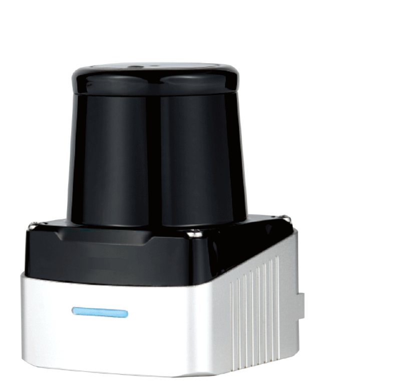
DLD-50D Housing — 60 × 60 × 80 mm, 148 g

DLD-50D LiDAR housing shown from two angles

Technical Data

ModelsDLD-50DH · DLD-50DC · DLD-50DP (Ethernet-output series)
Range @90% / @10% remission0.1–50 m / 0.1–20 m
Repeatability±20 mm
Field of view280°, blind sector 320°–0°–40° (80°)
Angular resolution / scan rateDLD-50DH: 0.08°/0.16°/0.32° @50 Hz · DLD-50DP: 0.32° @100 Hz
Ranging sample rate225 kHz
Laser905 nm, Class 1 eye-safe
Ambient light immunity> 100,000 lux
InterfaceEthernet 100BASE-TX — TCP data port 2368, UDP broadcast discovery, default IP 10.10.10.121; no NPN/PNP, relay or analog output
SoftwareSimiView point-cloud viewer (bundled) + DLD-50DSDK
Supply / consumption9–36 V DC (typ. 12 V) · 2.5 W
Enclosure / massIP67 · 60 × 60 × 80 mm · 148 g
Operating temperature−10 °C to +55 °C
ClassificationMeasurement/perception LiDAR — not IEC 61496 safety equipment

Not published by the factory (and therefore not claimed here): the full resolution-to-rate pairing matrix, ROS driver status and SDK language list, multi-echo behaviour, and enclosure material. Ask us to confirm any of these in writing. Certification documents are available on request. Same hardware with added NPN/PNP discrete I/O ships as DLD50T8N / DLD50T8P.

From Bench Test to a Useful Point Cloud

The scanner supplies measurements; mapping, localization and application decisions remain in your host software. Use this practical acceptance sequence with the English manual below.

  1. Confirm the delivered variant. Match the label, connector and ordered configuration with the manual before connecting power. Record the model, firmware and network settings for your project file.
  2. Establish a stable bench connection. Use a suitable supply and Ethernet connection, avoid address conflicts, and verify live data in SimiView before integrating a driver. Do not assume an SDK example is already compatible with your operating system or robotics middleware.
  3. Validate the actual mounting position. Check known objects at near and far working distances, identify the blind sector in the scan, and record any occlusion from brackets, loads or vehicle structure.
  4. Test the complete application. Log representative motion, lighting and target conditions. Agree pass/fail criteria for missing data, localization stability and host response; also test how the controller handles a disconnected or unavailable sensor.

Keep personnel-protection functions independent of this evaluation. Our guide to safety scanners versus navigation LiDAR explains why a good navigation scan is not evidence of a certified protective function.

Where Integrators Use It

AGV / AMR Localization

Ethernet point clouds feed SLAM and reflector-navigation stacks; 148 g and 2.5 W barely dent the battery budget.

Contour & Volume Scanning

0.08° resolution on the DH model densifies profiles for dimensioning, pile measurement and shape checks.

Outdoor Perception Zones

Sunlight-proof to >100,000 lux and sealed to IP67 for gates, yards and dock aprons — perception and early warning only.

Fast-Platform Obstacle Detection

The 100 Hz DP variant refreshes quickly enough for higher-speed vehicles and short control loops.

English User Manual & Project Support

PDF · English · 22 pages · approximately 25.5 MB

DLD-50D User Manual

Keep the manual beside your commissioning checklist. Confirm the exact variant and revision before applying connector, network or software instructions to the delivered unit.

For a focused recommendation, send your target material, required working distance, mounting sketch, controller/operating system and sample quantity through our application support contact. Include the full model code when requesting software or a wiring check. Browse the technical download center for other product documents.

Frequently Asked Questions

Why does repeatability matter more than accuracy for SLAM work?

A SLAM or reflector-navigation stack compares scan after scan; what corrupts the pose estimate is jitter between those scans, not a constant offset. The DLD-50D holds ±20 mm repeatability — the tightest in our LiDAR range — which shows up directly as steadier localization and cleaner accumulated maps. It is the one ranging figure the factory publishes for this model; if your calculation needs an absolute-accuracy number as well, ask us and we will confirm it in writing.

How should I orient the sensor given the 80° blind sector?

The aperture is 280°, with the blind sector spanning 320°–0°–40° in device coordinates. Mount so that dead zone faces something you never need to see — the vehicle body on an AGV corner, the wall behind a fixed installation. On a front-corner mount, the 280° window covers the travel direction and both flanks from a single unit.

What does commissioning look like — software, IP address, ports?

Power the unit (9–36 V DC), connect Ethernet, and the free SimiView tool discovers it over UDP broadcast and renders the live point cloud — the fastest way to verify mounting angle and blind-sector orientation across a fleet. Production data flows over TCP on port 2368; the default device IP is 10.10.10.121. The DLD-50DSDK is available for custom integration.

DLD-50DH or DLD-50DP — which one fits my project?

DH gives selectable 0.08°/0.16°/0.32° angular resolution at 50 Hz: choose it when point density decides the outcome, as in contour capture, volume measurement or detailed mapping. DP runs a fixed 0.32° at 100 Hz: choose it when your control loop is fast and refresh rate beats density, as in dynamic obstacle detection on quick platforms.

Will it keep measuring in direct sunlight or in the rain?

Ambient-light immunity is rated above 100,000 lux — the level of direct midday sun — so loading docks, gateways and skylit halls are within its design envelope, and the IP67 housing handles dust and temporary immersion. Multi-echo weather penetration is not documented for this model; if fog or heavy dust is central to your site, tell us and we will point you at the right unit.

Can the DLD-50D trigger a stop circuit or safety relay by itself?

No — its only output is Ethernet; there is no NPN/PNP, relay or analog channel, and no OSSD. This is a perception/measurement LiDAR, not an IEC 61496 certified safety component; do not use it as the sole means of personnel protection. Need hardwired switching from the same platform? See the DLD50T8N/P. Need a genuine safety function? Specify the ST27 Type 3 safety scanner.

How do ordering, samples and OEM projects work?

MOQ is 1 unit — most integrators start with a single evaluation sensor on the bench with SimiView. Lead time is typically 3–15 days depending on model and quantity, stated in writing on the quotation. Factory-direct export from China; OEM/ODM programs for fleet builders (labelling, cabling, parameter presets) are welcome via the inquiry form.