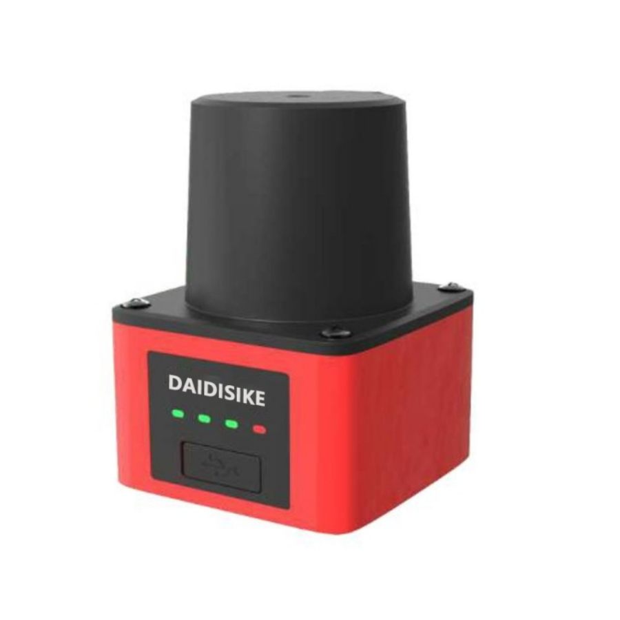
5JPTG/10JPTG 5-meter and 10-meter laser scanning ranging radar
The 5JPTG/10JPTG adopts an advanced laser scanning mechanism and precise signal processing algorithms. By actively emitting laser beams and accurately capturing the reflected signals, it can scan the surrounding environment. Its high-precision ranging and positioning capabilities enable the machine to accurately identify and avoid obstacles. It features high-speed scanning, high resolution, and can generate point cloud data of the environment in real time. It is widely used in automated production lines, intelligent warehousing, unmanned transport vehicles, robot navigation, and other fields.
The economic laser scanning ranging radar series includes two models: the 5JPTG (5m economic type) and the 10JPTG (10m economic type). These devices are advanced LIDAR solutions designed for obstacle avoidance and environmental perception in various automated systems.
The 5JPTG adopts a TOF (Time-of-Flight) solution with a 270-degree two-dimensional scanning range, achieving a measurement distance of up to 6 meters, distance accuracy of ±30mm, and an angular resolution of 0.5°. It supports multi-region monitoring, where each region can be divided into three sub-regions for comprehensive coverage. With 16 configurable region groups, it enables precise and flexible obstacle detection, making it ideal for high-availability applications like AGV trolleys. The device features high-speed scanning, real-time point cloud generation, and powerful data processing capabilities.
The 10JPTG is a compact, high-performance LIDAR with a 10-meter scanning radius, ±30mm ranging accuracy, and 270-degree coverage. It allows for three independent monitoring areas that can be freely set and edited using polygon, sector, or rectangle shapes. Its small size facilitates easy integration into drones, robots, and AGVs, while supporting customizable obstacle avoidance zones for enhanced safety and navigation.
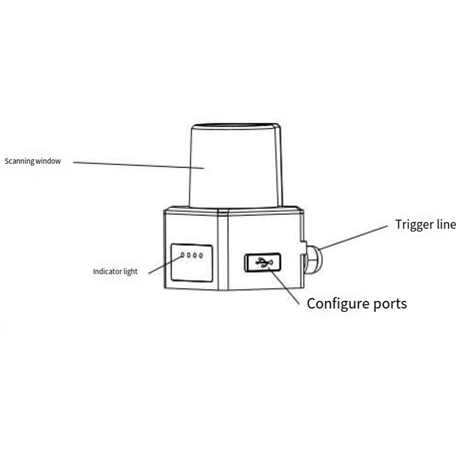
Both models include user-friendly host computer software (AGVConfigurator for 5JPTG and 10JPTG.exe for 10JPTG) for configuration via serial port or UDP, enabling area editing, point cloud visualization in editing or monitoring modes, parameter settings (e.g., response time, hold time, and obstacle size filtering), and firmware version querying. They also support IP configuration for network connectivity and have LED status indicators for operational feedback.
Product Working Principle
The laser scanning ranging radars (5JPTG and 10JPTG) operate on the Time-of-Flight (TOF) principle combined with precise signal processing algorithms. The device actively emits laser beams in a 270-degree scanning pattern using an advanced laser scanning mechanism. When the laser hits an object in the environment, the reflected signal is captured by the sensor.
The system calculates the distance to the object by measuring the time it takes for the laser pulse to travel to the target and return. This data is processed to generate high-resolution point cloud data in real time, representing the surrounding environment's geometry and obstacles. The angular resolution (0.5° for 5JPTG) ensures detailed mapping, while accuracy (±30mm) allows for reliable detection.
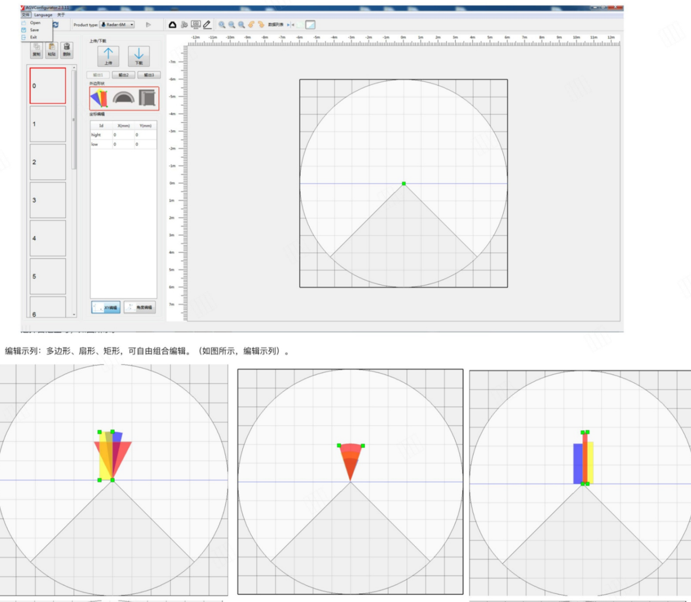
Configurable monitoring regions (up to 16 groups in 5JPTG and 3 independent areas in 10JPTG) can be defined using shapes like polygons, sectors, or rectangles. When an obstacle enters a defined region and meets criteria such as minimum response time or size threshold (e.g., at least 5 hit points to avoid filtering small interferences), the radar triggers outputs (e.g., alarms via I/O lines). Hold time ensures the output state persists briefly after the obstacle leaves, preventing rapid fluctuations. The radars support multi-input configurations (e.g., IN1-IN4 for region selection in 5JPTG) and can switch between regions dynamically for adaptive obstacle avoidance.
Product Application Scenarios and Environments
The 5JPTG and 10JPTG laser radars are versatile for environments requiring precise obstacle avoidance and navigation, particularly in industrial and automated settings. Key application scenarios include:
Automated Guided Vehicles (AGVs) and Unmanned Forklifts: Used in warehouses and factories for safe navigation around dynamic obstacles, with multi-region monitoring ensuring all-around protection during material handling.
Intelligent Warehousing and Logistics: High-speed scanning helps in path planning, collision prevention, and efficient space utilization in high-traffic storage facilities.
Robot Navigation and Drones: The compact design of the 10JPTG makes it suitable for integration into mobile robots or UAVs for obstacle detection in confined or outdoor spaces.
Automated Production Lines: High-speed scanning and point cloud generation enable machines to detect and avoid hazards, improving operational safety and efficiency in manufacturing environments.
General Industrial Settings: Applicable in scenarios with varying speeds and directions, such as conveyor systems or assembly lines, where customizable regions adapt to specific layouts.
IP66* (referring to the black detection cover, the whole machine is IP54)
Impact Resistance
Impact resistance 196m/s2 (20G) in X, Y, Z directions, 10 times.
Vibration Resistance
10 to 55Hz with a double amplitude of 1.5mm, lasting for 2 hours in each of the x, y, and z directions. (Including packaging) During operation: 55 to 150Hz with 19.6m/s² scanning for 2 minutes, lasting for 30 minutes in each of the x, y, and z directions. (Excluding packaging)
EMC
EN 61000-6-2:2005;EN 61000-6-4:2007+A1
Weight
374g(including cable)
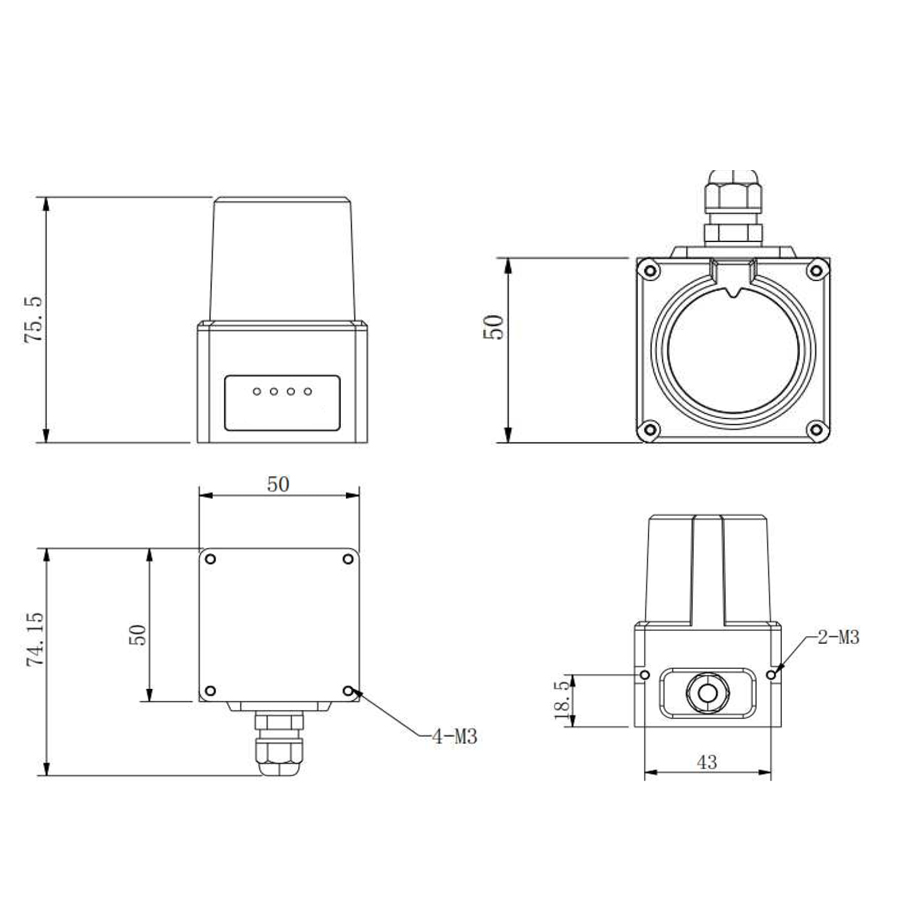
Dimensions
61x61x82mm
Frequently Asked Questions
What is the difference between the 5JPTG and the 10JPTG laser scanning radar?
Both are TOF (Time-of-Flight) 2D scanners with 270° coverage and ±30mm accuracy. The 5JPTG is the 5-meter economic model (up to 6m at 90% reflectivity) with 0.5° angular resolution and 16 configurable region groups. The 10JPTG is a compact 10-meter unit allowing three independent monitoring areas defined as polygon, sector, or rectangle shapes.
Can the 5JPTG/10JPTG be used for AGV and AMR obstacle avoidance?
Yes. With 270° scanning, 20Hz scan frequency and real-time point cloud output, both models are designed for AGV trolleys, unmanned forklifts and AMR mobile robots. Multi-region monitoring lets you map protective and warning fields around the vehicle, triggering I/O outputs when an obstacle enters a defined zone for adaptive obstacle avoidance.
Is the 5JPTG/10JPTG a safety-rated laser scanner under IEC 61496-3?
The 5JPTG/10JPTG is an economic obstacle-avoidance and navigation LiDAR, not a certified Type 3 safety device per IEC 61496-3. It is ideal for warning fields, collision prevention and point-cloud perception. For personnel-protection safety functions that must meet IEC 61496-3, pair it with a dedicated safety-rated scanner or controller.
What is the measurement range and accuracy of these radars?
The 5JPTG measures 0.1–6m at 90% reflectivity and 0.1–5m at 10% reflectivity, while the 10JPTG reaches a 10-meter radius. Both deliver ±30mm measurement accuracy and ≤20mm repeat accuracy with 0.5° angular resolution, a 905nm laser, 14.4kHz sampling and >50000lux ambient-light immunity for reliable indoor detection.
Can the 5JPTG/10JPTG replace a SICK or Pilz laser scanner for navigation?
For non-safety obstacle detection and navigation, the 5JPTG/10JPTG is a cost-effective alternative to SICK or Pilz scanners, offering 270° coverage, Ethernet plus serial output and configurable zones. Match the range (5m or 10m), DC9–36V supply and IP66 detection-cover rating to your application. For rated personnel safety, choose a certified safety scanner instead.